About the Portal
The Project Performance Monitoring System (PPMS) for Survey of India, Government of India, titled as “Pragati” Portal, is designed and developed by NIC Uttarakhand to monitor physical and financial progress of the projects being executed by Survey of India across the country. The “Pragati” portal tracks project processes on a continuous basis so that it could provide early warnings on delay in achievement of results..
As per generic design of the portal, any project can be defined using following three layer architecture :
• Project components
• Component wise list of Activities to be performed along with location(s) of component execution.
• Activity wise list of parameters to be monitored
A project once created by Head Office of Survey of India can be allocated to various State offices of SOI across the Nation. The respective State office can assign different components to its officers to fill defined parameters wise progress on real time basis. The officers at different levels can monitor & review the project progress through various types of dashboards and analytical reports as provided in the portal. The delay in progress can easily be tracked and highlighted on real time basis. Some of the major projects which are being monitored through the portal are:
• SVAMITVA Scheme for Department of Panchayati Raj(MoPR), Government of India
• National Hydrology Project
• Land Scale Mapping (LSM) Haryana
• Land Scale Mapping (LSM) Karnataka
• Land Scale Mapping (LSM) Maharashtra
• Land Scale Mapping (LSM) Andhra Pradesh
• Land Scale Mapping (LSM) Haryana
• Departmental Projects of Survey of India
• etc
About SVAMITVA Scheme
SVAMITVA Scheme is a Central Sector scheme launched by Hon’ble Prime Minister of India on National Panchayat Day i.e 24th April 2020. The Ministry of Panchayati Raj (MoPR) is the Nodal Ministry for implementation of the scheme. In the States, the Revenue Department / Land Records Department are the Nodal Department and carry out the scheme with support of State Panchayati Raj Department. The scheme seeks to achieve the following objectives: -
i. To bring financial stability to the citizens in rural India by enabling them to use their property as a financial asset for taking loans and other financial benefits.
ii. Creation of accurate land records for rural planning.
iii. Determination of property tax, which would accrue to the GPs directly in States where it is devolved or else, add to the State exchequer.
iv. Creation of survey infrastructure and GIS maps that can be leveraged by any department for their use.
v. To support in preparation of better-quality Gram Panchayat Development Plan (GPDP) by making use of GIS maps.
vi. To reduce property related disputes and legal cases
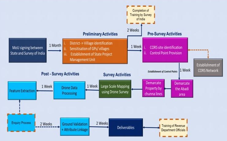
Survey of India is working as the technology partner for implementation. The major role of Survey of India in the scheme is:
1. Establishment of CORS network: Continuously Operating Reference Stations (CORS) is a network of reference stations that provide a virtual base station that allows access long-range highaccuracy Network RTK corrections. The CORS Network supports in establishing Ground Control Points, which is an important activity for accurate Georeferencing, ground truthing and demarcation of Lands.
2. Large Scale Mapping (LSM) using Drone: Rural inhabited (abadi) area would be mapped by Survey of India using drone Survey. It would generate high resolution and accurate maps to confer ownership property rights. Based on these maps or data, property cards would be issued to the rural household owners.
Functionalities
Real time management and monitoring of the projects.
Detailed Description of the project
A project can be described by its title, project funds, funding agency, timelines, its components, component wise activities and their parameters.
Flow based system
A project can be allocated to any office for its execution, who in turn can assign it to field level officer to fill progress on real time basis. The portal provide login-id & password based access for different level of officers. Users are authorized to use portal as per the roles defined for them in the system.
Provision to monitor the Financial progress
The portal has provision to monitor financial progress of the project. The parameters related to financial matters can be defied in the beginning of the project. The respective office can fill financial progress against prescribed parameters.
Progress Entry at field level
The physical progress in a project can only be filled by field level officer who is assigned by executing office. The progress entry once submitted cannot be edited or deleted by field level staff without approval of higher level officer.
Dashboard based
The dashboards, which are accessible only to senior level officers of SOI, provide real-time project progress by aggregating and extracting values, known as key performance indicators (KPIs) from all the project’s data entered by field level staff. The data made available in the form of visual information allows to see satisfactory progress in a project or highlight the area where there is delay in progress & improvement is required.
Integration with SVAMITVA Portal
The Pragati portal is integrated with SVAMITVA portal for updation of progress data on SVAMITVA portal. The progress in village wise drone flying, feature extraction, draft and final map generation etc as filled by field level staff of Survey of India is automatically updated on SVAMITVA portal through Web API.
Contact Us/Feedback
Office of the Surveyor General of India
Hathibarkala Estate, DEHRADUN, PIN - 248 001
helpdesk[dot]soi[at]gov[dot]in
+91-135-2747051/58